The following text is adapted from the field report submitted to Munjazat at the end of the 2012 field season, prepared by BUPAP directors, Susan E. Alcock and Chistopher A Tuttle.
The Brown University Petra Archaeological Project - 2012 Season
The third season of the Brown University Petra Archaeological Project (BUPAP) was conducted in the Petra Archaeological Park and its near environs for approximately a five-week period between June 18 and July 23, 2012. The BUPAP team was composed of some twenty-five archaeologists and other specialists. We would like to acknowledge from the outset our gratitude to the Department of Antiquities of Jordan, to Dr. Imad Hijazeen, Tahani al-Salhi, and Akram Atoom, as well as to all the residents of the Petra region for their warm hospitality.
As with our previous two seasons, the Project carried out several distinct, but overlapping research initiatives (Figure 1). Specific aspects of these undertakings included:
1) Petra Area and Wadi Silaysil Survey (PAWS)
a. Intensive regional survey in the landscape north of the Petra city center, extending from the modern village of Umm Sayhun to beyond the village of Bayda. Work was conducted on the north and east side of previously surveyed territory, notably around Bayda (defined as Area g) as well as at the southern extent (defined as Area h) (see Figure 1)
b. GIS mapping and recording of all archaeological features in these two Areas, in some cases accompanied by detailed architectural drawing c. Study and documentation of all collected ceramic and lithic finds
2) Test Square Excavations
a. A campaign of limited excavation at select features previously identified by the Project (see Figure 1)
b. Study and recording of all ceramic and lithic finds recovered c. Soil sampling, where possible, for projected palaeobotanical flotation, and phytolith analysis d. Taking of charcoal, soil and ceramic samples for the purpose of Optically Stimulated Luminescence (OSL) and radiocarbon dating
3) Petra Routes Project
a. Detailed reconnaissance, GIS mapping and recording of archaeological features in the Wadi Mu’aysara East and Wadi Mu’aysara West (see Figure 1)
b. Architectural drawing, visual representation, and analysis of built and rock-cut features in Wadi Mu’aysara East and West
4) Geophysical Prospection
a. Magnetometry and Ground Penetrating Radar reconnaissance at various features previously discovered by the Project
5) Wadi Baqa’ Water Management System
a. Documentation of terrace/dam features in the watershed of the Wadi Baqa’
b. Soil sampling and recording of soil parameters at various points in the system
c. Small test excavation aimed at investigating the construction of a particular terrace and at assessing the geomorphology of the area
d. Taking of soil samples for the purpose of Optically Stimulated Luminescence (OSL) dating e. Ground Penetrating Radar to elucidate the location of buried features within the water management system and their relationship to visible dams/terraces
A brief description of each of these initiatives follows, together with acknowledgement of the individuals who principally carried them out. A full report will be submitted for publication to the Annual of the Department of Antiquities of Jordan for 2013.
Petra Area and Wadi Silaysil Survey (PAWS) (Alex R. Knodell, Cecelia Feldman Weiss)
An approximately six-person survey team carried out a highly intensive survey in two areas (Areas g and h) in 2012; 396 Survey Units (or SUs) were walked in Area g, 56 in Area h (see Figure 1). The zones selected for coverage were designed to extend, to the north, south and east, the areas walked in 2010 and 2011 (Areas a, b, c, d, e, f).
As in previous seasons, our methodology involved careful reconnaissance of the earth’s ground surface, observing and counting all artifacts (chiefly ceramics and lithics) and collecting all ceramic pieces judged to be diagnostic as to function or date as well as all lithics. The team employed handheld GPS devices to map survey unit boundaries, allowing artifact densities and distributions to be accurately mapped. Figure 2 represents the ceramic densities discovered by the Project to date (from 2010-2012). Preliminary analysis, by Tali Erickson-Gini and Micaela Sinibaldi, report the presence of pottery ranging from the Early Bronze Age to the Modern period, as in previous seasons. Area g, however, yielded more Iron Age material than had been observed before, and a substantial Early Bronze Age site (Feature g232) — another period little represented before— was noted and subsequently explored through both geophysics and limited excavation.
Lithic finds were again numerous, remarkably so in Area g (Figure 3). Later prehistory (Chalcolithic and Bronze Age) remains best represented across the entire survey region; in Areas g and h, however, there was a very marked decline in the amount of Pre-Pottery Neolithic and Epipaleolithic material compared to previous seasons. Both Lower and Middle Paleolithic artifacts were found, including numerous Lower Paleolithic hand axes. Finally, the survey team continued the observation and counting of the modern debris (plastic, glass, metal) widely distributed across the landscape (Figure 4). Activity on the part of both local inhabitants and tourists appear responsible for the often very high densities of modern garbage.
As part of PAWS, a second ‘features’ team mapped and recorded all anthropogenic features in the survey landscape; these included such elements as walls, cisterns, water channels, rock reliefs, shrines and baetyls, and quarries (Figure 5). Several of these features are very complex in nature, with numerous individual rock-cut or built components. 310 features were recorded for Area g and 16 for Area h; the team also revisited Area c (first walked in 2010), recording 65 additional features. Finally, they explored Area s (with 22 features), a region only extensively walked in 2011. Such densities, combined with the over 600 features discovered in our previous two seasons, indicate the massive degree of human modification this landscape has experienced over the millennia.
Test Square Excavations (Clive Vella, Emanuela Bocancea)
Limited excavation was undertaken at ten locales previously noted by the PAWS survey (Figure 6), with the goal of both verifying the testimony of the surface record and seeking material to improve our understanding of ceramic chronologies. An additional objective of the test square excavations was to gauge the archaeological potential and the extent of modern damage in the sampled features, which were located both within and immediately outside the boundaries of the Petra Archaeological Park. These test squares included work at: structures in the village site of Ras al-Silaysil (Features b8 and b55); a shrine near Shamasa thought to be dedicated to the Nabataean deity Dushara (Feature a45); an extremely high quality limestone platform near the Islamic village of Bayda (Feature c66); a baetyl shrine, also near Bayda (Feature d97); two hilltop, stone-built structures (Features e207 and f56); a round building, possibly a silo (Feature e143); a terrace/dam in Wadi Baqa’ (Feature a138); and a Bronze Age hilltop settlement with a system of perimeter walls (Feature g232). Highlights of the excavations include the discovery of a fine paved limestone floor in the Dushara shrine near Shamasa (Feature a45, Figure 7), a dense ceramic concentration accumulated in front of a stepped baetyl shrine (Feature d97, Figure 8), a sealed Nabataean deposit in an outlook post containing an intact flagstone floor alongside crushed pottery and a fireplace (Feature f56, Figure 9), and a cooking surface above a burnt structure at the Bronze Age site (Feature g232, Figure 10). Ceramic samples were taken for Optically Stimulated Luminescence (OSL) dating from several of the test squares. Geophysical work was also conducted at several of these locations and the features have been drawn to a very high architectural standard.
Petra Routes Project (Michele Berenfeld, Felipe Rojas)
The Petra Routes Project (PRP) continued to work to explore and document routes in and out of Petra, notably through fieldwork in Wadi Mu’aysara East and Wadi Mu’aysara West, which connect the city center with the PAWS survey territory to the north. The team of architects and archaeologists has meticulously documented these two wadis, noting and mapping features such as agricultural installations and terraces, cisterns, ritual sites, tombs and roads. These are now integrated in the same GIS database as all features from the PAWS survey. Very high quality and innovative drawings and other artistic representations were created of this wadi system by architects from Brown University and the Rhode Island School of Design, exploring new ways to capture and document the unusual rock-cut architecture of the Petra region.
Geophysical Prospection (Thomas Urban, Susan Herringer)
In the 2012 field season the BUPAP geophysical team conducted non-invasive investigations at four sites north of Petra. These included the Wadi Baqa’ Water Management System, the Islamic village at Bayda, the forecourt of a Nabataean tomb near Siq al-Barid, and a Bronze Age site near the modern village of Bayda (feature g232). The primary instrument deployed at the first three sites was a ground penetrating radar (GPR), which effectively located numerous architectural features within all areas explored. Work in Wadi Baqa’ included virtual reconstructions of three buried terraces/dams using GPR data (Figure 11). In the Islamic village, an open area between two excavated structures was surveyed with GPR, revealing a number of previously unknown walls in the sub-surface. With the Bronze Age site, both GPR and magnetic methods were used. This offered the detection of both architectural features and heat-intensive features, in addition to yielding useful information about natural and anthropogenic site formation processes. Excavation at the Bronze Age site later revealed a cooking surface that had generated a large anomaly in the magnetic survey.
Wadi Baqa’ Water Management System (Emanuela Bocancea, Thomas Urban, Clive Vella)
In 2010, an extended and well-preserved series of terraces/dams was discovered and recorded during the PAWS intensive pedestrian survey in Wadi Baqa’, immediately East of the Bayda-Umm Sayhun road. Further exploration identified and documented additional elements of this system in 2011. In 2012, the geophysical work already mentioned above (see Figure 11) helped elucidate the location of buried terraces/dams and their relationship to visible structures and natural features. Additionally, the team undertook a study of various soil parameters, including moisture retention, pH, and sediment grain size within the water management system – both upstream (in the Shara mountain range) and downstream (near the confluence with Wadi Silaysil) from the area containing the well-preserved dams/terraces. A small test square was placed behind one of the best-preserved terrace walls in Wadi Baqa’ (part of Feature a138, see Figures 12-13) to assess both the construction of the wall and the geomorphological characteristics of the sediments built up behind it. This small excavation also yielded samples for Optically Stimulated Luminescence (OSL) dating which will be compared with OSL samples recovered from an exposed wadi scarp upstream from Feature a138
Looting and Vandalism
It is with great distress that we report what appears to be a significant increase in looting activity and vandalism within the project’s research area, both in the Petra Archaeological Park and within its buffer zone to the east. Several new looting trenches were noted at places previously visited and recorded by the BUPAP team, and at least one baetyl feature (d60, with an accompanying inscription) has been severely vandalized since 2011 (Figure 14). In at least two of the features where BUPAP test squares were placed (a45 and g232, where looting had previously taken place), individuals came and illicitly dug into our trenches during the night, doing further damage to the archaeological record. We are happy to provide more details on this unfortunate activity.
Figures
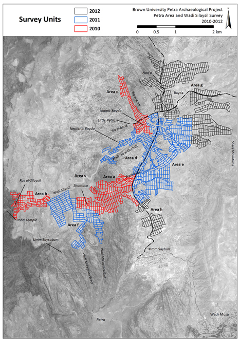
Figure 1: Overall map of the BUPAP Study Area, 2010-2012 (image courtesy Alex R. Knodell)
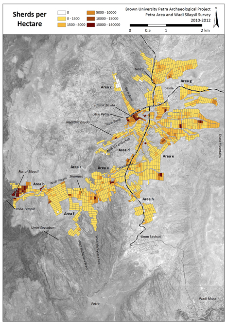
Figure 2: Overall ceramic density by survey unit, Petra Area and Wadi Silaysil Survey 2010-2012 (image courtesy Alex R. Knodell)
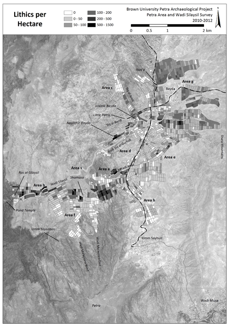
Figure 3: Overall lithic density by survey unit, Petra Area and Wadi Silaysil Survey 2010-2012 (image courtesy Alex R. Knodell)
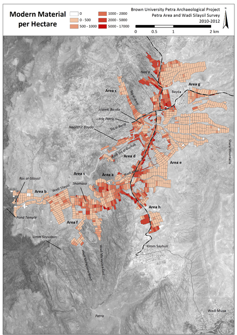
Figure 4: Overall modern density by survey unit, Petra Area and Wadi Silaysil Survey 2010-2012 (image courtesy Alex R. Knodell)
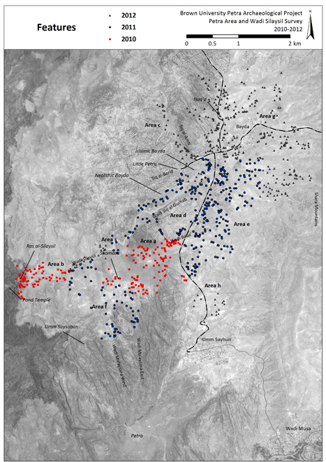
Figure 5: Overall map of feature distribution, Petra Area and Wadi Silaysil Survey 2010-2012 (image courtesy Alex R. Knodell)
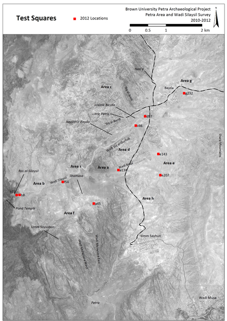
Figure 6: Overall map of test square locations (image courtesy Alex R. Knodell)
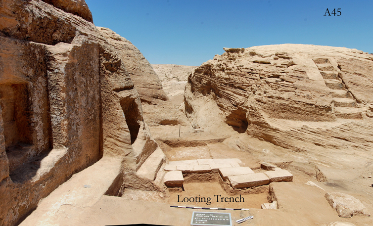
Figure 7: View of test square excavation at Feature a45, the Dushara shrine near Shamasa (image courtesy Emanuela Bocancea and Clive Vella)
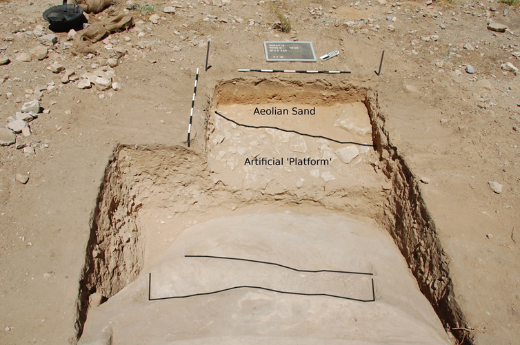
Figure 8: View of test square excavation at Feature d97, in front of a stepped baetyl shrine near Nabataean/Islamic Bayda (image courtesy Emanuela Bocancea and Clive Vella)
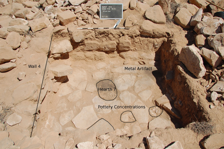
Figure 9: View of test square excavation at Feature f56, an outlook post containing an intact flagstone floor alongside crushed pottery and a fireplace (image courtesy Emanuela Bocancea and Clive Vella)
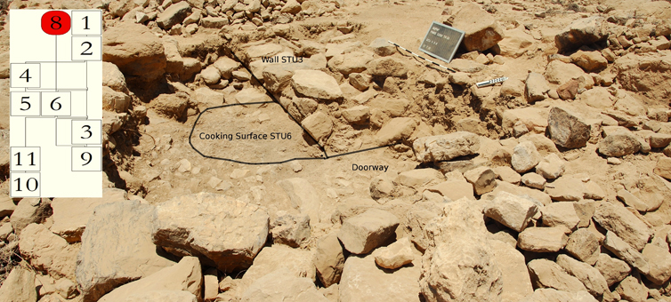
Figure 10: View of test square excavation at Feature g232, a cooking surface above a burnt structure, at the Bronze Age site, with associated Harris matrix (image courtesy Emanuela Bocancea and Clive Vella)
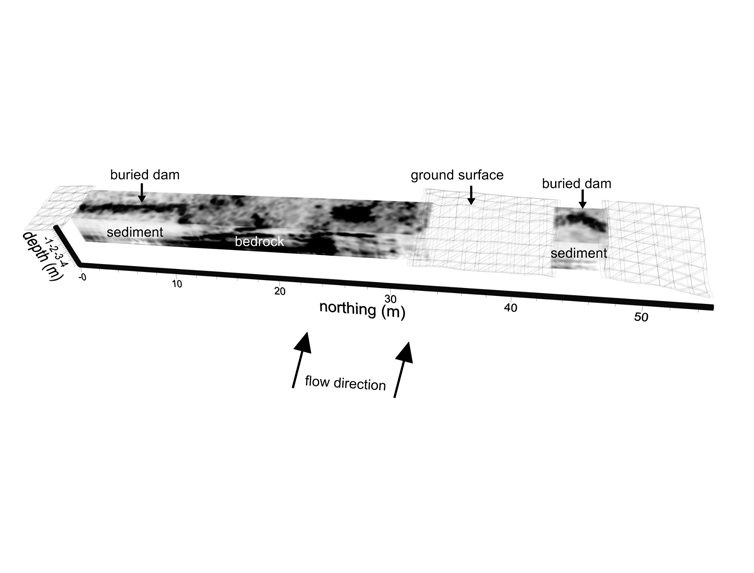
Figure 11: Results of ground penetrating radar (GPR) work in Wadi Baqa’, with virtual reconstructions of three buried terraces/dams (image courtesy Thomas M. Urban)
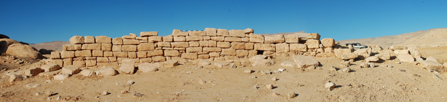
Figure 12: View of well-preserved terrace wall in Wadi Baqa’, part of Feature a138 (image courtesy Emanuela Bocancea and Clive Vella)
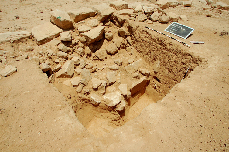
Figure 13: View of test square excavation at Feature a138, behind well-preserved terrace wall in Wadi Baqa’ (image courtesy Emanuela Bocancea and Clive Vella)
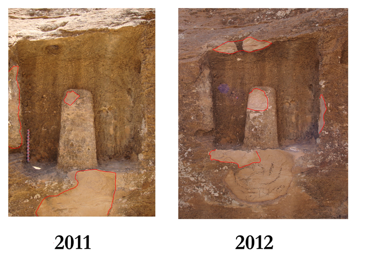
Figure 14: Baetyl feature (d60) in the Petra Archaeological Park, photographed in 2011 and 2012, and showing signs of recent vandalism (image courtesy Emanuela Bocancea and Clive Vella)
Home | People | PUMA | PAWS | BIV | PRP | The 2010 Season | The 2011 Season | The 2012 Season | Bibliography | JIAAW | Credits
